Erraid, Mull-The Tidal Island- Historic Stevenson lighthouse Island- Treasure island?

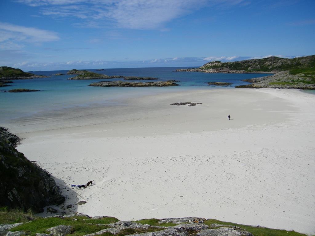
Traigh Gael or Stevenson's Kidnapped "Balfours Bay" a lovely cove!
CLICK ON PHOTOS BELOW TO ENLARGE

Fidden Farm the road to the Erraid boat starts here.Ben More in the background
The small tidal isle of Erraid( c lick for walk) lies 200 metres off the south west tip of the Ross of Mull, about 300 hectares and Mull's third largest off-shore island, about four miles drive from Fionnphort. For an hour or two either side of low water, the island is linked to the Ross by a broad expanse of sand along which, people can walk across to Erraid. Seaview bed and breakfast is ideally located for your visit to Erraid.
Please make sure that you get the tide times right and that you get local advice before going across. Click on this link for tide times.
HOW TO GET THERE
From Fionnphort village on the Ross of Mull's western tip, the only road leaving the village is to Knockvologan, winding south past beaches and sands, through Fidden Farm and across desolate peat bog, four miles to Knockvologan Farm and access to Erraid. Fidden Farm is owned and run by Jimmy & Christine Campbell. As well as rearing cattle and

the Erraid sound at low water the road to the Isle of Erraid
sheep, they run a traditional campsite on the sandy machair, right on the beach overlooking Erraid and Iona.
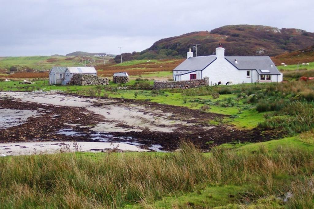
On passing Fidden, to the south you will catch a glimpse of Erraid's row of granite houses and walled gardens. Also to the south east, in the distance, a narrow channel, dry and sandy only until an hour before high tide, dividing the island from the main island of Mull.
Towards Knockvologan on either side of the road on the peat bogs there is evidence of peat cutting, a fuel source for the locals in bygone days.
South west across Knockvologan beach to Erraid south shore
Peat burning has seen something of a come-back since the economic crash of 2008. On the grassy verge on your left before the white bungalow and 200 yards before the Knockvologan gate and barns, there is an area where you can park your car.Please do not park your car in front of the farm buildings as access is required at all times by the farmer. On leaving the car, walk along the road to the farm gate (look out for the farmers sign advertising where you can buy cuts of their lamb), go through the gate and follow the road 300 yards or so to Knockvologan Farm House which is on your left. Please remember to keep dogs on leads at all times, as livestock roam in and around the farm yard as well as down on the beach.

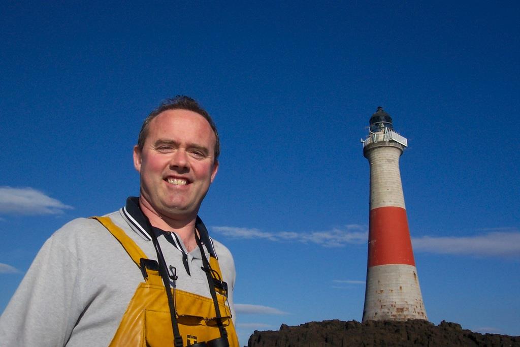
Stevenson lighthouse Dubh Artach (black pebble) or St Johns rock 14 miles south west of Erraid
From the farm, keep on the track and walk south down the track to the beautiful Knockvologan sands and beaches stretching east and west, turn right (west) and follow the rough track on to the machair to the broad channel of sand running south the north between Mull and Erraid. It is important you have the correct tidal information and follow local advice at this point. If you get it right you can have up to 3 or 4 hours on Erraid. If you get it wrong you have a long wait for low tide or you get very wet!
To access Erraid walk north up the sandy channel and cross on to Erraid at the north end of the channel.
Erraid is a beautiful, rugged small island in a very remote part of the western seaboard of Scotland. However, history has made it more than that as Erraid is also the backdrop of one of Scotland's most famous romantic novels 'Kidnapped' by Robert Louis Stevenson and as the working stone centre of a major engineering achievement - the construction of the famous Stevenson rock lighthouse 'Dubh Artach', 15 miles south southwest of Erraid on a desolate wind swept rock, protecting seafarers from the ravages of the Torran Rocks.
The old Erraid schoolhouse cottage
Thereafter Erraid was used as accommodation for the Lighthouse Keepers families while their men manned Dubh Artach and Skerryvore Lighthouses.

Jacob Sheep
Now, having landed on the northeast corner of Erraid on your right (to the north) is the tidal sound of Erraid, a haven for birds particularly migrant waders and passerines including corncrake, lapwing, skylark, sedge, warbler, hen harrier, merlin, peregrine, sanderling, sandpipers, godwits, barnacle and greylag geese.

Erraid pier boathouse and cottages
Walking west along the sandy north shore of Erraid you will come to a white croft cottage (formerly the old school house on the island) overlooking a sandy bay with views towards Fidden. On passing the croft cottage, the track rises up to the former lighthouse keepers cottages and along the outside of the magnificent granite garden walls to a wooden farm gate. Go through the gate. To the north is the splendid stone pier which is worth a look. To the south, follow the track south, up the hill past the cottages to the quarry where the Erraid granite was extracted for the building of Dubh Artach lighthouse.
Follow a path to the top of a knoll above the quarry cottage (now a ruin) to the disused lighthouse observatory station. From here the views are a

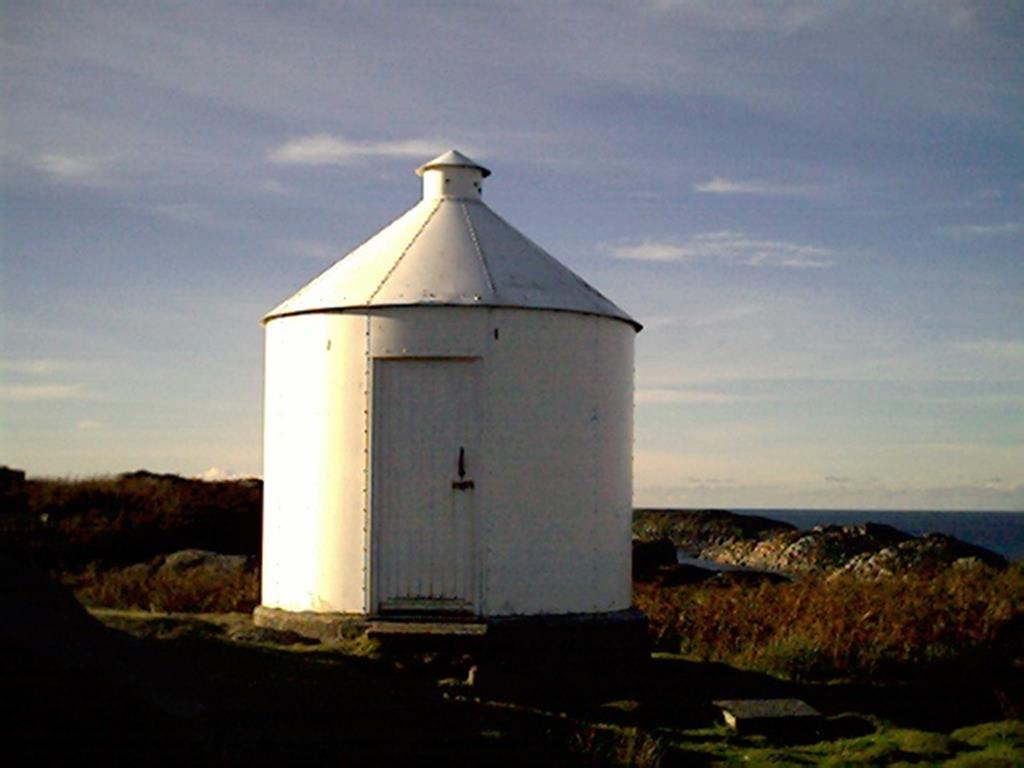
Old stone platform for boat navigation light
stunning panorama of the surrounding area and this is where John proposed to Jane one rather glorious October day in 2005, and so Erraid has a special significance to both of us. On a clear day there are splendid panoramic views of Iona, her Abbey, the Ross of Mull and Ben More to the northwest, north and northeast. And to the south and west, the treacherous Torran Rocks, Dubh Artach lighthouse and Skerryvore lighthouse. This walk takes about 30-40 minutes from Knockvologan and the easiest route back is to retrace your steps - stopping off on the way back to enjoy the white sandy beaches at Knockvologan.
To Balfours Bay (or Traigh Ghael)
From the white ex schoolhouse on the north shore of Erraid, walk up the slope behind the croft in as south-
The lighthouse signal station on the hill above the cottages
south-westerly direction. There is a rough track where the land

Quarry and quarry house
becomes heathery and boggy. Near the top of the slope over its crest, there is a shallow valley facing south west. Follow the valley for half a mile, and descend onto the secluded sandy cove with azure blue waters known as Balfours Bay. (See History of Erraid below). It is an ideal spot for a barbeque or a picnic and for the real 'rufftie tuffties' perhaps a 'wee dook in the water'. On return, retrace your steps to the croft. For walkers wishing to follow in David Balfour's footsteps from Erraid to Edinburgh, further information about the route he took and how to replicate it, have a look at Stevenson's Way website.
SHORT HISTORY OF ERRAID
Erraid is made from granite rock which cooled about 420 million years ago and took its present shape from the last ice age. Evidence of human occupation is from the early Christian age, although it is known that various tribes occupied the western seaboard long before that. There is a 'dun' or fort from around 250 AD, (Dun Aoidhean) on the top of the hill at the north east corner of Erraid.

basalt dyke in Erraid Granite on SW tip Erraid
For hundreds of years after this with the western seaboard being a major trade route these lands would be occupied by and fought over by the Picts, Celts, Vikings, and the Clans MacLean and Campbell. The local people would have been simple farmers raising Kyloe cattle (black Highland cattle), growing potatoes and barley and fishing for fish and shellfish. Scottish Gaelic was spoken and the landlords encouraged the collecting of kelp for export, lowland sheep and young men to join the army to increase their revenue from the area.
The Duke of Argyll, for economic reasons, the potato blight and the ever-increasing population on the island in the 1840s, led to part of the now famous Highland Clearances and a mass exodus of the Ross of Mull's peoples to America, Canada and Australia.

Pier Cottage towards pier
In the 1860's the Northern Lighthouse Board decided on the construction of a lighthouse on a rock outcrop called 'Dubh Artach' (Black Pebble), 15 miles south west of Erraid and at the western edge of the infamous Torran Rocks where over 20 ships were sunk between 1865 and 1866. David & Thomas Stevenson, lighthouse construction engineers were chosen and they transformed Erraid into a major construction site, building Erraid's street of dressed granite stone houses, the pier and Dubh Artach lighthouse. Thomas Stevenson's son Robert Louis Stevenson, the famous Scottish writer, visited Erraid on several occasions and thereafter used Erraid and Traigh Ghael on the south coast of Erraid as a backdrop to part of his novel 'Kidnapped' where the hero, David Balfour is shipwrecked on the Torran Rocks and washed ashore on what is Ghael, now referred to as Balfour's Bay (Traigh). In Stevenson's novel 'Treasure Island', Jack Hawkins chart bears a resemblance to Erraid.

Former lighthouse families cottages
Most of Erraids buildings are on the hillside above the pier are nine solid cottages with large walled gardens to the north side. Between the cottages and the pier there is a boathouse and cottage. All the cottages are constructed from granite stone from the Erraid quarry above and to the south west of the cottages. The stone has been dressed to a remarkable high quality and 150 years later the stone has hardly weathered at all. The same can be said of the granite base at Dubh Artach lighthouse today after 150 years of Atlantic gales pounding against the stone, when John visited the lighthouse in his boat Wanderer, he didn't notice any cracks, breaks or weathering in the granite stone. The construction is amazing when you take into account that the lighthouse was built using only hammers, chisels and an extraordinary amount of skill. The cost of the shore station construction on Erraid totalled £10,000, a huge amount of money in those days.

Pier boathouse
The shore station served the Northern Lighthouse Board, the lighthouse keepers and their families of Dubh Artach and Skerryvore lighthouses well into the 1950's when due to the mechanization of the lighthouses, permanent lighthouse keepers were no longer required, the station was closed and the people were transferred to Oban on the mainland. Erraid was put up for sale and the island was purchased by a business man from Glasgow who used it as a holiday home and for inspiration for a children's story entitled 'The Island' written by his wife.
In 1977 a Dutch family, the Van der Sluis' bought the island. A year later they offered it to the to look after on condition that for one month during the summer they would return to enjoy the freedom and adventure of the island. The Foundation agreed to become custodians and a small group of intrepid members moved to the island, restored the cottages and started a vibrant and welcoming spiritual community. In the same year Christine Gibson came to live permanently at the croft, becoming a powerful matriarchal figure on the island. She is buried close to the croft which remains in the Gibson family and is the only part of the island not cared for by the community. Findhorn Foundation
THE SIGNAL STATION ON ERRAID

John and Andrew at the signal station a few years ago
Situated on a hill south west of the cottages is the now disused signal station (observatory) although it has been renovated in recent years, which kept in contact with Dubh Artach and Skerryvore lighthouses before the days of telephone and radio communications.
The lighthouse keepers were often isolated from their families for up to three weeks, and during winter gales this could be for months. Communication between the lighthouses and shore stations was always important. In the early days Morse code was used to signal between the stations and lighthouses. By means of a very powerful telescope lenses inside the signal tower, if there was a large black bell showing at the lighthouse it meant that the keepers wanted to communicate. The letters of the alphabet were indicated by showing a bell at long and short intervals. Later a heliograph in which a mirror flashed a faster signal was used. In 1929 Marconi telephones were introduced and the signal station became redundant.
DUBH ARTACH LIGHTHOUSE
Facts and Figures: completed in 1872 by engineers Thomas and David Stevenson; 44 metres high from sea level, the tower of grey granite from Erraid is 38 metres high with a broad red painted band, situated 15 miles from Erraid and mainland Mull, lying to the south west on the desolate, windswept, storm bound, 230 feet long by 35 feet high treacherous St. John's rock or Dubh Artach (Black Pebble).
John at the lighthouse in his boat the wanderer
The lighthouse was built to safeguard shipping between Islay lighthouse and Skerryvore lighthouse, keeping the ships to the west of the dangerous Torran rocks, where many vessels had been lost. The lighthouse took six years to complete. Stonemasons from Aberdeen quarried, cut and chiselled the grey granite on Erraid to an exact specification and the stone was then transported out to Dubh Artach in the summer months for construction on the exposed reef - the equivalent of completing a jigsaw after a journey to the moon!
On 29 November 1871 the masonry was completed.. The tower was solid to the 21st course; the tower door was 31 feet above rock ground level; the tower base was 36 feet in diameter at the bottom and 16 feet at the top. There were seven living compartments and the whole outer course and face was made of granite. The total cost of building it was £83,710. This engineering feat was truly remarkable considering the remoteness and severe weather conditions encountered.

Quarry house with Iona and sound behind
Robert Louis Stevenson described it thus "35 feet above high water at its summit, the swell breaks at one end, runs cumulating round either side and meets and breaks again at
the opposite end, so that the whole rock is girdled with broken water. There is no sheltered bight. If there is anything to aggravate the swell, and it is wonderful what a little thing it takes to excite these giant waters, landing becomes impossible on Dubh Artach"
In the summer of 1870 for example, for 62 days they were able to land stones and supplies at Dubh Artach. However during the entire four year period, the rock was only accessible by boat for 91 days and during this time 3115 tons of stone were landed!

Quarry House and Fidden Sands Mull
If you are interested in exploring Erraid, please ask John or Jane for advice - OS Map explorer 373 Ross of Mull, Iona and Staffa
Contact Us:
John & Jane Noddings
Seaview Bed & Breakfast, Fionnphort, Isle of Mull, Argyll, Scotland, United Kingdom PA66 6BL
Tel +44(0)1681 700235 Mob: (07708) 556311 Email: john@seaview-mull.co.uk
Find us on Facebook and TripAdvisor
Last amended 31/03/2021
© 2001-2021